District Profile
Wakiso District was established in the year 2000 after being carved out of Mpigi District. It comprises the three original counties of Mpigi—Busiro, Kyadondo, and Entebbe Municipality. The district is predominantly inhabited by the Baganda ethnic group, with Luganda being the widely spoken language.
Strategically located in Uganda's Central Region, Wakiso partly encircles Kampala, the capital city of Uganda. The district headquarters are situated in Wakiso Town, approximately 20 kilometers northwest of Kampala, along the Hoima Highway. The district also hosts Kira Municipality, the second-largest urban center in Uganda.
Vision, Mission, and Motto
Vision: “A transformed community from semi-peasantry to a modern and urbanized district within 30 years.”
Mission: “To serve the people of Wakiso to improve their quality of life.”
Motto: “Together we win”
Location and Size
Wakiso shares borders with, Nakaseke and Luweero Districts (North), Mukono District (East), Kalangala District (South, via Lake Victoria), Mpigi District (Southwest), and Mityana District (Northwest).
Covering a total area of 2,807.75 square kilometers, Wakiso is part of the historically significant Luwero Triangle—once ravaged by war but now a thriving urban hub. As per the 2024 National Census, the district is Uganda’s second most populated, with a total population of 3,307,700, nearly half of whom live in urban areas.
Administrative Structure
Wakiso District comprises of; 2 Counties: Busiro and Kyadondo, 6 Sub-Counties: Mende Sub-County, Masulita Sub-County, Bussi Sub-County, Namayumba Sub-County, Kakiri Sub-County and Wakiso Sub-County, 4 Municipality: Entebbe Municipal Council, Kira Municipal Council, Nansana Municipal Council and Makindye Ssabagabo Municipal Council, 9 Town Councils: Kasangati Town Council, Masulita Town Council, Kasanje Town Council, Namayumba Town Council, Katabi Town Council, Kakiri Town Council, Kyengera Town Council, Kajjansi Town Council and Wakiso Town Council.
All these Sub-Counties, Town Councils, and Municipal Divisions are designated as Lower Local Governments (LLGs) and function as self-accounting entities with corporate status.
Strategic Objectives
Promote quality and sustainable economic infrastructure development.
Enhance household incomes via small-scale enterprise and agricultural productivity.
Increase access to quality health, education, and social services.
Strengthen governance, accountability, and transparency at all levels.
Foster the use of ICT in service delivery and innovation.
Ensure sustainable land use and environmental conservation.
Encourage inclusive stakeholder participation in all government programs.
Developmental Objectives
Improve administrative efficiency at both district and lower local government levels.
Enhance financial resource mobilization and management.
Build human resource capacity for effective service delivery.
Expand and maintain high-quality physical infrastructure.
Promote gender equality and mainstream gender responsiveness.
Leverage ICT to improve governance, planning, and public service delivery.
Land Tenure System
Wakiso has four major land tenure systems:
Mailo Tenure – Introduced during the 1900 Buganda Agreement.
Freehold Tenure – Common among institutions such as religious bodies.
Leasehold Tenure – Grants usage rights for a specific period.
Customary Tenure – The oldest form, prevalent among the local population.
Demographic Characteristics
Total Population: 3,307,700 (2024 Census)
Population Growth Rate: 4.1%
Population Density: 700 persons/km²
Gender Ratio: 90 males per 100 females
Urbanization Rate: Approximately 50%
Geographical Features
The district falls within the Buganda surface classification, ranging from 900 to 1,340 meters above sea level. The landscape features flat-topped hills, broad valleys, and gently sloping pediments, split between two main zones:
Lake Victoria Zone (southern lowlands)
Highland Zone (central and northern hills)
Climate
Wakiso experiences a warm and humid climate conducive to agriculture, but also susceptible to disease outbreaks due to high humidity and rainfall.
Rainfall Pattern: Bimodal
Wet Seasons: April–May and October–November
Dry Seasons: January–February and July–August
Annual Mean Rainfall: ~1,320 mm, reaching up to 2,000 mm in Lake Victoria zones
Temperature Range:
Minimum: 11.0°C
Maximum: 33.3°C
Peaks: February (hottest), July (coolest)
Wetlands
The district hosts numerous seasonal and permanent wetlands, especially in Entebbe and along the Lake Victoria shoreline. Dominant vegetation includes Papyrus and Miscanthus. However, wetland degradation through farming, construction, and excavation remains a major environmental concern. Community Wetland Management Plans have been developed for areas such as Zziba, Mende, and Lutembe.
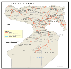
Map of Wakiso District

Latest Publications
Read our latest news. Be always in trend with daily news.


